By Alyssa Schnugg
News editor

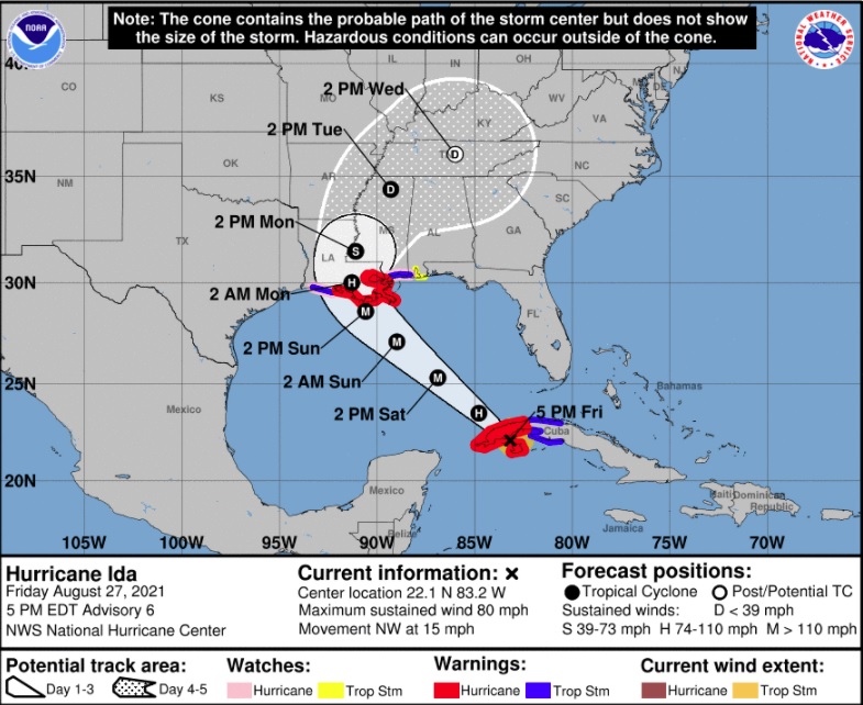
Hurricane Ida continues to make its way toward the central Gulf Coast, bringing the potential of life-threatening storm surge Sunday along the coasts of Louisiana and Mississippi.
North Mississippi, including Lafayette County, is expected to see 4 to 6 inches of rain associated with Ida that is forecasted to drop down to a tropical depression by the time it reaches north Mississippi, according to the National Hurricane Center.
Heavy rainfall, gusty winds and a possible few short-lived tornadoes are possible Monday and Tuesday in north Mississippi.
Watching the Coast
The forecast indicates possible landfall Sunday between Port Arthur, Texas, and Biloxi, Mississippi, with an emphasis on the Louisiana coast; however, this can still change as the storm advances.
Ida is likely to undergo rapid intensification as it moves across the hot Gulf of Mexico waters and is forecast to reach Category 3 status on Sunday. Hurricane-force winds are expected Sunday, and potentially catastrophic wind damage is possible when the eye of the storm moves onshore.
The storm surge inundation of 10 to 15 feet above ground level is possible within the area of Morgan City, Lousiana, to the Mouth of the Mississippi River.
A hurricane watch is in effect for New Orleans and a long stretch of Louisiana’s coast.
This is a developing story. Check with Hotty Toddy News for updates.

