

By Alyssa Schnugg
News editor
alyssa.schnugg@hottytoddy.com
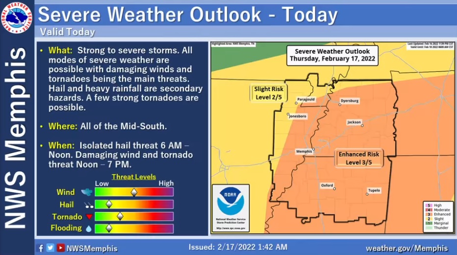
Lafayette County has been upgraded to an “enhanced risk” for severe weather this afternoon by the National Weather Service in Memphis.
The NWS uses a 1-5 scale to measure the risk of severe weather – 1-marginal, 2-slight, 3-enhanced, 4-moderate and 5-high.
A level 3 or enhanced risk deals with numerous and persistent severe storms with a few intense ones that could produce a few tornadoes and wind damage.
Rain will continue on and off this morning with a slight risk of hail, but the main risk for severe storms is forecast to be between noon and 6 p.m.
High winds are the biggest threat as they increase to 20-30 mph with gusts at 40-50 mph this afternoon as a cold front pushes into the area.
Some trees are weakened from the recent ice and sleet storms and high winds could see limbs and trees being knocked down by the winds leading to power outages. The high winds could also make travel hazardous.
The afternoon storms will have the potential to produce damaging winds and even a few tornadoes. This severe weather threat remains contingent on the amount of instability this afternoon. According to the NWS, if the sun peeks out, the severe weather potential will increase. If it’s raining all morning into the afternoon, the threat will decrease.
The cold front will drop the temperature rapidly today, with a high reaching 72 degrees and then dropping down to about 24 degrees tonight.


