By Alyssa Schnugg
News editor
alyssa.schnugg@hottytoddy.com
As the old upper low weakens through New Mexico, a dryline will form over Texas and set the stage for a potentially active Easter weekend in terms of heavy rain and severe weather in the Mid-South.
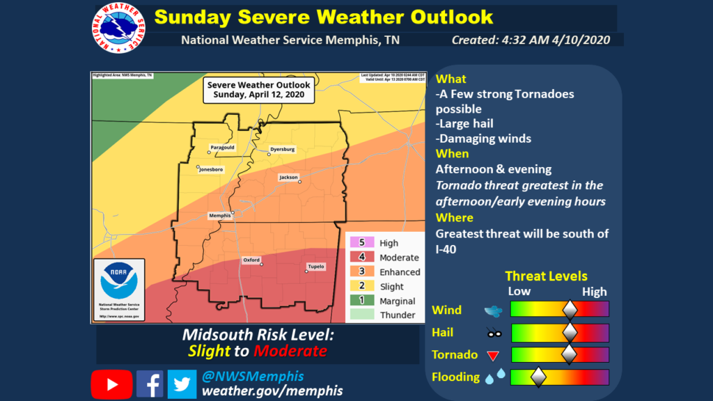
As of Friday, Lafayette County is currently listed as having a “moderate risk” of severe weather by the National Weather Service. Moderate Risk is the second-highest risk category.
The preliminary data is showing the most severe weather taking place in the afternoon or early evening Sunday. The primary risk is tornadoes that could be strong and long-stretching, with secondary risks of hail and damaging winds. Localized flooding is also possible, according to the NWS-Memphis meteorologists.
The NWS urges residents to prepare now for the severe weather by updating weather plans – where to go if a tornado warning is issued in your home or other shelters; have multiple ways to receive weather warnings using cell phone apps, weather radios; build an emergency kit with nonperishable food, water, batteries, medications, flashlights and other items.
Oxford residents can sign up to receive local emergency alerts through Nixle by texting 38655 to 888777 from a cell phone or by registering online at oxfordms.net and signing up via the Nixle widget.
All Lafayette County and Oxford residents can also sign up for CodeRed, a weather warning and emergency notification service that alerts residents via cellphone, landline, texts and emails.
CodeRed has mobile apps available on Google Play and the Apple App Store.
In the city of Oxford, storm shelters are located on most city properties. For a listing of Lafayette County storm shelters, visit https://lafayettems.com/how-do-i/find-a-storm-shelter/.


